The genius of SUPER drone’s two-trajectory strategy
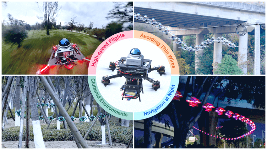
Traditional drone navigation systems rely on pre-mapped environments or slow real-time calculations, limiting their ability to react dynamically. However, researchers from the University of Hong Kong have developed the safety-assured high-speed aerial robot (SUPER) – a compact MAV with a 280-millimeter wheelbase and a thrust-to-weight ratio greater than 5.0. This next-generation autonomous drone can make split-second decisions using LiDAR-based perception, real-time mapping, and a two-trajectory strategy.
Its advanced navigation system allows SUPER to navigate complex environments at high speeds while avoiding obstacles in real time. By integrating LiDAR sensing and an intelligent planning framework, the drone ensures both agility and safety – even in completely unknown terrain.
The key innovation behind SUPER is its two-trajectory planning system, which allows it to explore new paths while always maintaining a backup plan for safety:
- Exploratory Trajectory – Charts a fast, efficient path toward its goal, even through unknown spaces.
- Backup Trajectory – Ensures the drone can always return to a known safe space if the exploratory path encounters obstacles.
This system recalculates trajectories 10 times per second, allowing SUPER to react instantly to changes in its surroundings and avoid collisions – even at high speeds. If a replan fails, SUPER will execute the last committed trajectory – guaranteeing safety by ensuring that the drone never enters unknown or hazardous areas without a way back.
One of the biggest challenges in real-time drone navigation is quickly and accurately understanding the environment. The SUPER system tackles this with a sophisticated LiDAR-based perception module:
- The drone’s LiDAR sensor captures 200,000 points per second, detecting obstacles over 70 meters away.
- A dynamic mapping system ensures only relevant data is stored, preventing clutter that could slow down calculations.
- A sliding-point cloud strategy removes outdated information (e.g., moving objects that are no longer present), preventing false obstacle detection.
This level of perception allows SUPER to navigate efficiently through forests, urban environments, and disaster zones, where obstacles are unpredictable and constantly changing.
What makes this navigation system truly unique is its real-time backup corridor generation – a safety-first approach that ensures the drone always has a collision-free escape route.
Using a novel CIRI algorithm (Configuration-Space Iterative Regional Inflation), the system extracts safe flight corridors directly from LiDAR data. Unlike older methods that rely on pre-mapped environments or computationally expensive occupancy mapping, CIRI enables real-time safe zone generation, significantly reducing processing overhead.
- CIRI ensures that every backup corridor is fully contained within known free space, preventing navigation failures.
- The system accumulates recent LiDAR scans (1-2 seconds) to improve corridor accuracy.
- Even with limited LiDAR field-of-view CIRI dynamically adjusts the backup zone to guarantee safe rerouting.
By eliminating the need for ray-cast occupancy mapping, this breakthrough enables high-speed UAV operations in challenging and unpredictable environments.
The ability to generate safe, real-time backup trajectories marks a major leap forward in autonomous drone technology. This innovation is ideal for:
- Autonomous drone deliveries in complex urban environments.
- Search-and-rescue missions in disaster zones.
- Military reconnaissance in unknown or high-risk areas.
- Precision agriculture, where UAVs scan large fields with minimal delay.
By combining high-speed flight, real-time mapping, and intelligent navigation, SUPER pushes the boundaries of what autonomous drones can achieve. As these capabilities continue to evolve, we may soon see drones navigating complex environments with the same agility and awareness as real pilots – if not better.